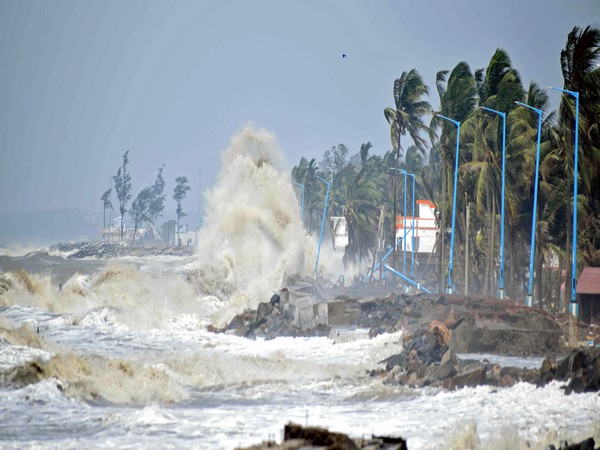
West Bengal, May 28 (ANI): A view of sea waves at Tajpur beach aftermath of cyclone Yaas in East Midnapore on Friday. (ANI Photo)
New Delhi [India], October 25 (ANI): Under the influence of Cyclone Sitrang, a red alert indicating heavy to very heavy and extremely heavy rainfall has been issued for Assam, Meghalaya, Mizoram, and Tripura on Monday. Widespread rainfall accompanied by thunderstorms, lightning, and heavy to very heavy and extremely heavy rain at isolated places is very likely to occur over Tripura on Monday and Tuesday, said the India Meteorological Department (IMD) on Monday.
“Under Sitrang influence, widespread rainfall accompanied by thunderstorms/lightning/heavy to very heavy and extremely heavy rain at isolated places is very likely to occur over Tripura on 24th & 25th October 2022,” IMD said in a press release. Earlier today, the West Bengal government was witnessed taking all the precautionery measures, including evacuation of people, and supply of relief material to shelters, to deal with possible devastation under the impact of Cyclone ‘Sitrang’.
Civil defence teams are deployed at Bakkhali Sea Beach in South 24 Parganas. Tourists are not allowed to visit the beach and the shops have also been closed.
West Bengal Chief Minister Mamata Banerjee on Monday appealed to the people to “stay alert” as there is a high chance of rain on Tuesday due to cyclone Sitrang. “There is a high chance of rain on October 25. There is an appeal to the people to avoid going out unnecessarily or to the sea areas including the Sundarbans. The state govt has made arrangements,” said CM Mamata Banerjee.
The cyclonic storm “Sitrang” pronounced as “Si-Trang” over the northwest and adjoining the central Bay of Bengal crossed the Bangladesh coast between Tinkona and Sandwip close to Barisal during 9:30 pm to 11:30 pm on Monday with a maximum sustained wind speed of 80-90 kmph gusting to 100 kmph, IMD said.
“It lay centered at 11:30 pm on Sunday over coastal Bangladesh near latitude 23.70N and longitude 90.80E, about 40 km east of Dhaka, 50 km west-southwest of Agartala, and 120 km north-northeast of Barisal (Bangladesh),” IMD officials said. “The cyclone is very likely to continue to move north-northeastwards and weaken into a depression during next 6 hours and further into a well-marked low-pressure area during subsequent 6 hours,” it further said.
Cyclone Sitrang: Vizag Coast Guard shepherds fisher boats to return harbor

Vishakhapatnam (Andhra Pradesh) [India], October 24 (ANI): The Indian Coast Guard has asked the fishermen to return with their boats as the fear of Cyclone Sitrang grips. In an attempt to ensure safety of the people, the Indian Coast Guard Ship Sagar is making efforts to keep the fishing boats at sea.
“#CoastGuard Region East remains committed to ensure safety of fishermen. Amidst the fury of developing cyclone in #BayofBengal, @IndiaCoastGuard Ship Sagar maintains its efforts to ensure safety of all fishing boats at sea. All fishing boats being shepherded to return harbor,” Defence PRO Visakhapatnam tweeted.
The scientist of India Meteorological Department (IMD) Umashankar Das told ANI that the north coastal Odisha is expected to get some heavy rainfall. “Heavy to very heavy rainfall expected over West Bengal and a few northeastern states, particularly Tripura, Meghalaya, and south Assam,” IMD Scientist Umashankar Das told ANI in Bhubaneswar.
He further said that the cyclone ‘Sitrang’ is moving north-northeastwards at a speed of 15kmph since last six hrs. “The cyclone is expected to intensify further into a severe cyclonic storm during next 12 hrs and then continue its movement and is likely to cross Bangladesh coast between Tinkona Island and Sandwip early morning tomorrow,” he said.
According to the IMD, the cyclonic storm ‘Sitrang’ was then situated about 520 km south of Sagar Island and 670 km south-southwest of Barisal in Bangladesh. “To move north-northeastwards and intensify further into a severe cyclonic storm in the next 12 hrs. To cross the Bangladesh coast between Tinkona Island and Sandwip,” the IMD said.
At 3.17 am on Monday, the cyclone was 520 km south of Sagar Island in West Bengal and 670 km south-southwest of Barisal in Bangladesh, as per IMD. The forecasting agency further said, “It is very likely to continue to move north-northeastwards and intensify further into a severe cyclonic storm during the next 12 hours. Continuing to move north-northeastwards thereafter, it is very likely to cross Bangladesh coast between Tinkona Island and Sandwip close to Barisal around October 25 early morning.”
In the wake of Cyclone Sitrang, it had issued an advisory pertaining to the suspension of offshore activities in the north Bay of Bengal from October 24-25 along with issuing a warning of the possible impact of the storm in North and South 24 Parganas and East Midnapore districts of West Bengal.
“Due to the cyclonic storm over West Central Bay of Bengal and adjoining East Central Bay of Bengal and its likely intensification into a severe cyclonic storm, fishermen are advised not to venture into the sea till 25th Ocober 2022,” IMD‘s statement said.
Predicting the possible damages, the department said that thatched huts would likely be damaged.
As per its advisory, the department suggested major damage to Kutcha and minor damage to Pucca roads and waterlogging in the Corporation and Municipality low-lying area. The release from the department said that wind speed reaching 40-50 kmph gusting to 60 kmph and gradually increasing becoming 60-80 mph gusting to 90 kmph is likely over North and South 24 Parganas and East Midnapore districts on Monday.
The administration has deployed civil security forces to protect the river banks of South 24 Parganas in West Bengal and it is also making the arrangements to move people along the river banks to safer places. In the Chunokhali Basanti area of South 24 Parganas, the river embankment repair work is going on before the storm. Civil defence forces are being deployed by the administration in the Gangasagar area of the state. (ANI)
Cyclone ‘Sitrang’ to cross Bangladesh coast
The cyclonic storm “Sitrang” pronounced as “Si-Trang” over the northwest and adjoining the central Bay of Bengal moved north-northeastwards with a speed of 28 kmph during the past 6 hours on Monday evening, an official statement said.
“The cyclone is very likely to continue to move north-northeastwards and is expected to cross Bangladesh’s coast between Tinkona Island and Sandwip close to Barisal in the intervening night of Monday and Tuesday,” the communique said.


